International Year of Artisanal Fisheries and Aquaculture
Designing a mobile app that identifies in real time the fishing activity of vessels
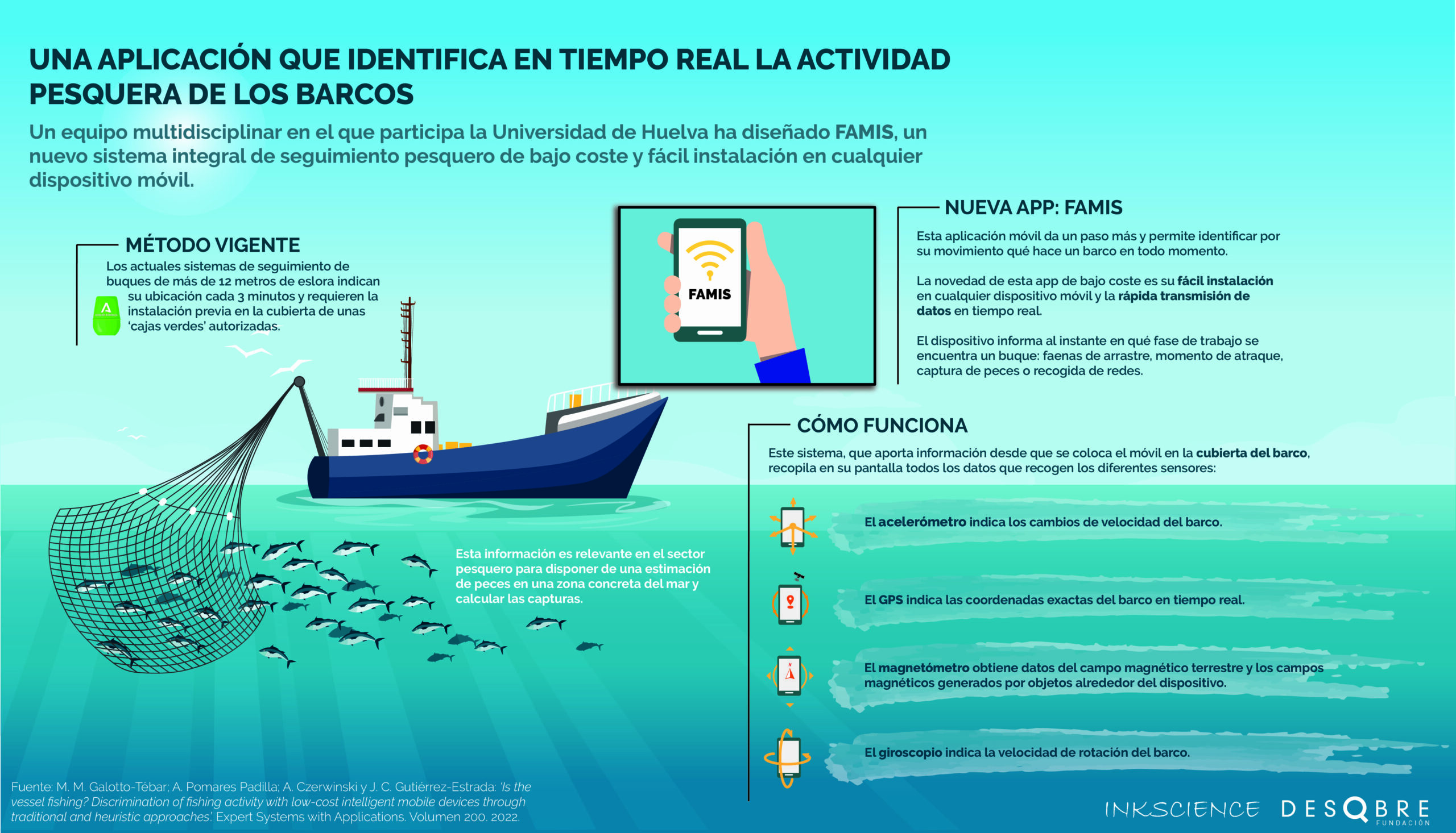
A multidisciplinary team from the University of Huelva, the Miguel Hernández University and the Spanish Institute of Oceanography (IEO) has developed a device that uses different sensors integrated in smartphones to instantly detect from the movement of the boat whether it is performing trawling tasks, whether it has docked after stowing its fishing nets or is simply sailing out or back on a working day.
A multidisciplinary team made up of experts from the University of Huelva, the Miguel Hernández University and the Spanish Institute of Oceanography (IEO) has designed an innovative integrated system for monitoring fishing activity based on the use of sensors usually installed in a smartphone to detect in real time and according to the movement of the vessel what type of fishing activity is being carried out on board. This information is relevant in the fishing sector for estimating the amount of fish in a specific area of the sea and calculating catches.
The novelty of this low-cost app is its easy installation in any mobile device and the fast transmission of data in real time, in under a second. In addition, as reported in the study entitled ‘Is the vessel fishing? Discrimination of fishing activity with low-cost intelligent mobile devices through traditional and heuristic approaches’, published in the journal Expert Systems with Applications, this tool makes it possible to determine with great precision where the vessel is located, regardless of its size, and how much time it spends fishing.
This mobile app, called FAMIS, provides instant information on the working phase of a vessel. In this respect, the time a vessel spends fishing is a determining factor for assessing fishing effort, that is, for calculating the amount of catches in a particular area and the amount of fish that may be present in that place at that precise time.
Current systems for monitoring fishing vessels indicate the location of boats over a longer time interval -approximately at least every 3 minutes-, require prior installation on the deck of the vessel and are controlled by the relevant fishing authorities.
These are tracking systems similar to GPS that send a signal to land. «This tool allows us to know the position of a boat, but during its stay at sea we don’t know how much time it has spent casting the nets, fishing and collecting all the material. The FAMIS app goes further and makes it possible to identify from the movement of the vessel what fishing manoeuvre it is carrying out at all times,» Fundación Descubre was told by Juan Carlos Gutiérrez Estrada, researcher at the University of Huelva and one of the authors of this study.
The experts, specialized in Computer Science, Biology and Marine Science, have applied this system because both smartphones and tablets carry integrated sensors that allow to identify the movement of the ship from the data they record. «Depending on the type of manoeuvre (whether the boat is accelerating, pitching, rolling, etc.), the vessel has a characteristic movement that is reflected in the accelerometer. They also allow us to know whether the vessel is casting its net, fishing or retrieving its gear,» says Gutiérrez Estrada.
Artificial intelligence on board
This system, which sends information as soon as the mobile phone is placed on the deck of the boat, has been tested using different statistical methods and artificial intelligence models based on artificial neural networks and support-vector machines. The app displays numerically and graphically on its screen all the information captured by the different sensors: GPS, accelerometer, gyroscope and magnetic field. The most efficient model will be integrated into the app and will provide information about the activity that the boat is performing in real time.
To demonstrate the usefulness of these sensors, tests were carried out from the oceanographic vessel Miguel Oliver on one of its voyages. This 70-metre long and 12-metre wide vessel is equipped with technological equipment for navigation and for fishing and oceanographic research. «This boat makes it possible to record 4 to 6 net hauls per day, and to obtain data under very adverse conditions, given its large displacement and the lightweight characteristics of the fishing gear used for sampling,» says the co-author of this study.
According to the experts, the model can be used with any type of vessel, as it can be calibrated and adapted for use on small boats. «The main advantage of this app for the fishing industry is its ability to count the fishing effort, a fundamental parameter for estimating the relative abundance of fish in the sea,» says Gutiérrez Estrada.
Spanish version: Diseñan una app móvil que identifica en tiempo real la actividad pesquera de los barcos
References
M. M. Galotto-Tébar; A. Pomares Padilla; A. Czerwinski and J. C. Gutiérrez-Estrada: ‘Is the vessel fishing? Discrimination of fishing activity with low-cost intelligent mobile devices through traditional and heuristic approaches’. Expert Systems with Applications. Vol. 200. 2022.
Más información:
#CienciaDirecta, agencia de noticias de ciencia andaluza, financiada por la Consejería de Universidad, Investigación e Innovación de la Junta de Andalucía, con la colaboración de la Fundación Española para la Ciencia y la Tecnología-Ministerio de Ciencia e Innovación.
Teléfono: 958 63 71 99. Extensión 205
Últimas publicaciones
Un equipo de investigación de la Universidad de Sevilla ha identificado un sistema rápido, no destructivo y que puede emplearse 'in situ' en las bodegas para seleccionar orujo de la uva blanca y reutilizarlos para disminuir hasta un 50% la aspereza de este producto vitivinícola.
Sigue leyendoLa Sociedad Andaluza para la Divulgación de la Ciencia y la Fundación Descubre, promovida por la Consejería de Universidad, Investigación e Innovación, organizan este foro de ideas en el que un grupo de estudiantes aborda temas científicos relacionados con el calentamiento global y la crisis ambiental.
La clausura de esta iniciativa, en la que se celebra la asamblea final, ha estado presidida por el consejero de Universidad, Investigación e Innovación, José Carlos Gómez Villamandos, y la vicepresidenta del Parlamento de Andalucía Ana Mestre.
Se trata de una lámina delgada que recubre nanogeneradores que producen electricidad mediante el impacto de las gotas de lluvia. Además, al mismo tiempo, mejora la durabilidad de las celdas fotovoltaicas. El trabajo, desarrollado por el Instituto de Ciencia de Materiales de Sevilla (ICMS) abre nuevas vías para desarrollar sistemas electrónicos autónomos destinados a ser utilizados en exteriores.
Sigue leyendo